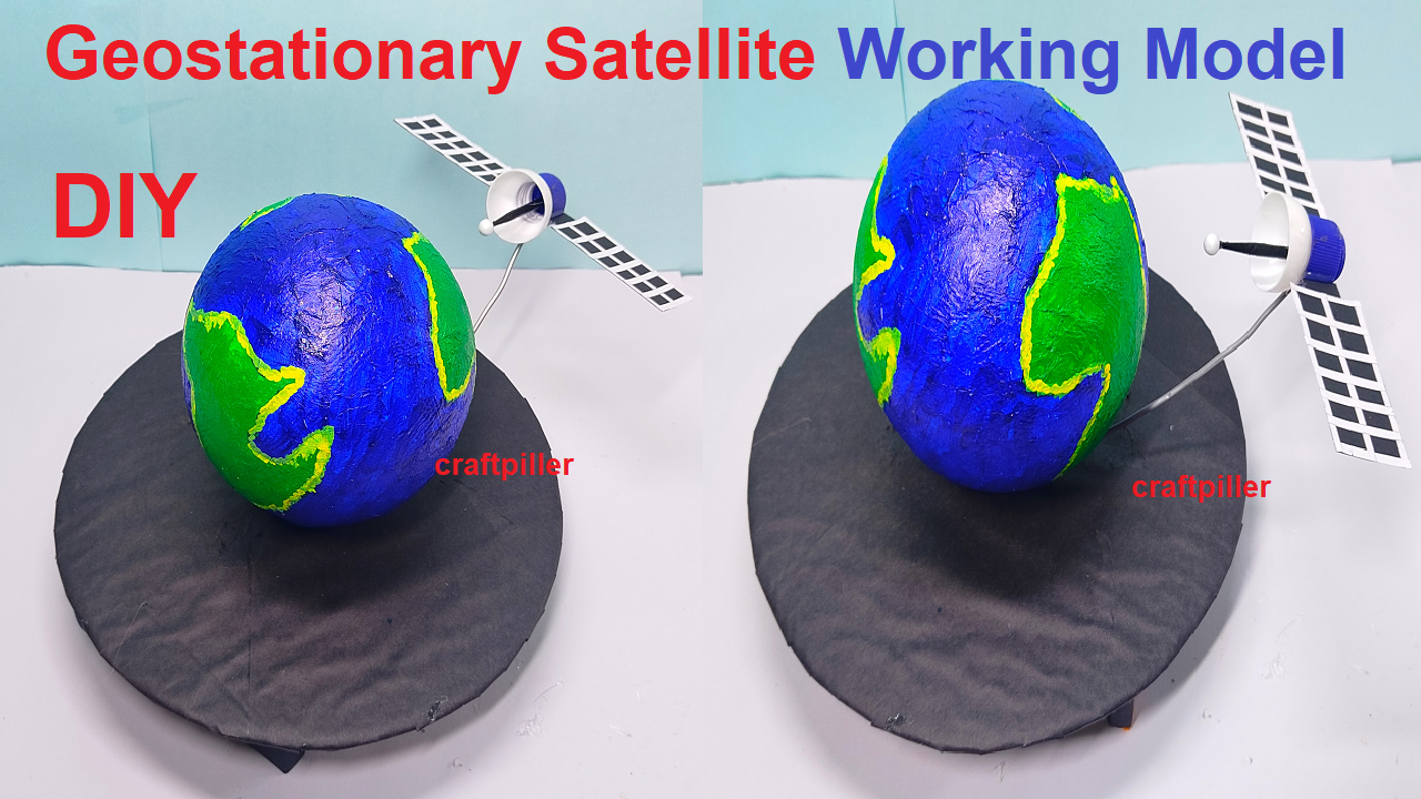
What is geostationary satellite?
A geostationary satellite is a type of satellite that is placed in a geostationary orbit, which is an orbit that is located at an altitude of approximately 36,000 kilometers (22,000 miles) above the Earth’s equator.
This orbit is chosen because it matches the Earth’s rotation, which means that the satellite appears to be stationary in the sky from a fixed point on the Earth’s surface.
How geostationary satellite works?
The working model of a geostationary satellite is based on its ability to remain in a fixed position relative to the Earth.
This is achieved by placing the satellite in an orbit that has the same period of rotation as the Earth (24 hours).
As the Earth rotates, the satellite remains in the same position relative to the Earth’s surface, which allows it to provide continuous coverage to a specific geographic region.
Geostationary satellites are primarily used for telecommunications, including television and radio broadcasting, internet services, and telephone communication. They are also used for weather forecasting, military communication, and tracking ships and planes.
geo stationary satellite working model for science project exhibition – diy – simple | craftpiller #geostationarysatellite #workingmodel #scienceexhibition #sciencemodel #scienceproject #craftpiller #workingproject #sciencefair #sstproject #sst
Steps for making the geostationary satellite working model

A geostationary satellite working model can be made using balls and a DC motor to demonstrate the concept of a geostationary orbit.
- The model can be made by suspending a ball (representing the satellite) from a fixed point using a string or wire.
- The DC motor can be used to rotate the string or wire, simulating the Earth’s rotation, while the ball remains in a fixed position.
- Here are the steps to make a simple geostationary satellite model using a ball and a DC motor:
- You will need a large ball (such as a beach ball), a DC motor, a string or wire, a battery, and a switch.
- Attach the string or wire to the ball: Tie one end of the string or wire to the ball, making sure the knot is secure.
- Attach the DC motor to the fixed point (such as a ceiling or a stand) using screws or other fasteners.
- Tie the other end of the string or wire to the shaft of the DC motor.
- Connect the battery to the DC motor using the switch.
- Turn on the switch and the DC motor should rotate, causing the string or wire to rotate with it, simulating the Earth’s rotation.
- The ball should remain in a fixed position, simulating a geostationary satellite.
- You can also add a solar panel and a communication antenna to the model, to make it more realistic.
- Please note that this is a basic model, for educational purpose only. It is not a functional satellite and cannot be used for real-world applications.
Step by steps video on making of the geostationary satellite working model
What are the main uses of geostationary satellites?
The main uses of geostationary satellites include telecommunications, such as television and radio broadcasting, internet services, and telephone communication. They are also used for weather forecasting, military communication, and tracking ships and planes.
How is a geostationary orbit achieved and why is it important?
A geostationary orbit is achieved by placing a satellite in an orbit that has the same period of rotation as the Earth (24 hours). This is important because it allows the satellite to remain in a fixed position relative to the Earth’s surface, providing continuous coverage to a specific geographic region.
Can you explain the difference between a geostationary satellite and a low Earth orbit satellite?
A geostationary satellite is placed in an orbit that is located at an altitude of approximately 36,000 kilometers (22,000 miles) above the Earth’s equator, whereas a low Earth orbit satellite is placed in an orbit that is located at an altitude of less than 2,000 kilometers (1,200 miles).
A geostationary satellite remains in a fixed position relative to the Earth’s surface and provides continuous coverage to a specific geographic region, while a low Earth orbit satellite passes over different parts of the Earth as it orbits and may have a lower signal strength and limited coverage area.
How do geostationary satellites contribute to weather forecasting and climate monitoring?
Geostationary satellites are equipped with sensors that can measure various weather-related parameters such as temperature, humidity, wind speed, and precipitation. The data collected by these satellites is used to produce weather forecasts and to monitor climate patterns over time.
How do geostationary satellites help in communication and what are the advantages of using them?
Geostationary satellites are used to transmit and receive signals for a variety of communication services, such as television and radio broadcasting, internet services, and telephone communication.
The advantages of using geostationary satellites include their ability to provide coverage to remote or underserved areas, their ability to provide continuous coverage to a specific geographic region, and their ability to reach areas that are difficult to cover using terrestrial networks.
How do geostationary satellites contribute to navigation and transportation?
Geostationary satellites are used to provide navigation and positioning services, such as GPS and GLONASS, which are used by ships, airplanes, and ground vehicles to determine their location and navigate. They are also used to track ships and planes and provide communication services to them.
What are some of the challenges and limitations of using geostationary satellites?
Challenges and limitations of using geostationary satellites include their high cost of deployment and maintenance, their vulnerability to interference

