
The Earth has distinct temperature zones that result from variations in the amount of sunlight received at different latitudes. These temperature zones are primarily determined by the Earth’s axial tilt, which causes varying angles of sunlight throughout the year.
The main temperature zones are as follows:
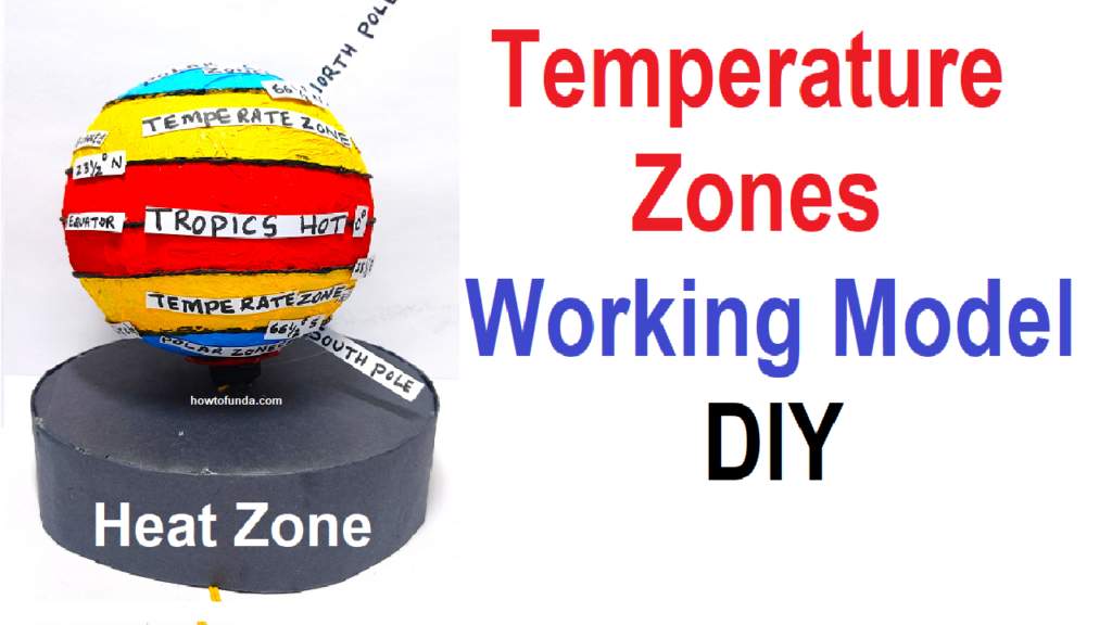
- Tropical Zone:
- Location: Between the Tropic of Cancer (approximately 23.5 degrees north latitude) and the Tropic of Capricorn (approximately 23.5 degrees south latitude).
- Characteristics: Warm temperatures throughout the year, with minimal seasonal temperature variation. This region receives direct sunlight, leading to a consistent warm climate.
- Subtropical Zone:
- Location: Between the Tropics and the Tropics of Cancer and Capricorn and the 30th parallel in both hemispheres.
- Characteristics: Generally warm temperatures, but with more pronounced seasonal variations than the tropical zone. The subtropical zones often experience hot summers and mild winters.
- Temperate Zones:
- Location: Between the 30th and 60th parallels in both hemispheres.
- Characteristics: Moderate temperatures with distinct seasons. The temperate zones experience warm summers and cool to cold winters. There is a noticeable difference in temperature between summer and winter.
- Polar Zones:
- Location: Beyond the 60th parallel in both hemispheres, approaching the poles.
- Characteristics: Cold temperatures throughout the year, with extreme cold in winter. Polar zones experience long periods of daylight in summer and extended darkness in winter due to the Earth’s axial tilt.
Creating a working model of the temperature zones of the Earth for a science project can be a fun and educational experience. Here’s a simple DIY guide using easily available materials:
Materials Needed:
- Styrofoam or cardboard globe: To represent the Earth.
- Acrylic paint or markers: For coloring the Earth.
- Desk lamp or flashlight: To simulate the sun.
- Push pins or small flags: To mark the temperature zones.
- Thermometer: To measure temperatures.
- String or yarn: To create temperature zone boundaries.
- Small pieces of colored paper: To label and represent different climate zones.
- Scissors and glue: For cutting and attaching elements.
Step by Step Video Instructions:
- Prepare the Earth Model:
- Use a styrofoam or cardboard globe as your base. Paint it or use markers to color it like the Earth, including continents and oceans.
- Sun Simulation:
- Position a desk lamp or flashlight to simulate the sun. This light source will represent the sunlight hitting the Earth.
- Mark the Equator:
- Attach a string or yarn horizontally around the middle of the globe to represent the equator.
- Mark the Tropics and Polar Circles:
- Use push pins or small flags to mark the Tropics of Cancer and Capricorn, which are approximately 23.5 degrees north and south of the equator, respectively.
- Mark the Arctic Circle and Antarctic Circle, which are approximately 66.5 degrees north and south of the equator.
- Create Temperature Zones:
- Divide the globe into different temperature zones. You can use colored paper to represent these zones, attaching them above and below the equator as follows:
- Tropical Zone: Near the equator.
- Subtropical Zone: Between the Tropics and the Tropics of Cancer and Capricorn.
- Temperate Zones: Between the Subtropical Zones and the Polar Circles.
- Polar Zones: Near the poles.
- Divide the globe into different temperature zones. You can use colored paper to represent these zones, attaching them above and below the equator as follows:
- Label the Zones:
- Attach small pieces of colored paper with labels to represent each temperature zone. Include information about the typical climate and temperatures in each zone.
- Measure Temperatures:
- Use a thermometer to measure the temperature in each zone under the light of the “sun.” Record and compare the temperatures in different zones.
- Explain the Project:
- During your presentation, explain how the Earth’s axial tilt and the position of the sun influence temperature variations in different zones.
- Discuss the characteristics of each temperature zone and how they contribute to the Earth’s climate.